|
Cemetery
Reading
| ||||||||||||||||||||||||||||||||||||||||||||||||||||||||||||||||||||||||||||||||||||||||||||||||||||||||||
| Cemetery Name: |
Frazier |
|
| County: | Putnam | |
| USGS Quad: | Mount Olive Map | |
| Coordinates: | 38.58152ºN -82.00545ºW | |
| Maintained by: | Unknown | |
| Land owner: | Ronald C. Harris | |
| Date added to WVCPA register: | February 2009 | |
| Condition of cemetery**: | Good (September 2009) | |
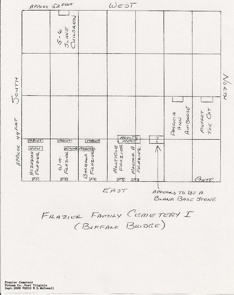
| Accessibility: | This cemetery is located off the entrance to the new Rt. 35 (to the north) from the old Rt. 35 (now Rt. 817) about 3/8 mile west of Buffalo Bridge. Access road & pond on right (w/ locked gate) leads to chain link fenced cemetery which measures approximately 44 feet X 52 feet. Cemetery is hidden by trees from road. | |
|
may not be representative of care at other times of the year Scale: Excellent - Good - Fair - Poor - Abandoned |
||


| Last Name: | First Name: | Born: | Died: | Inscription: | Photo: | Source: |
| 1850 | "5 or 6 Slave Children At
Rest Here Approx. 1850" "By B.B. Frazier 1992" |
|
|
|||
| Ambrose | Muffet | 1985 | [Beloved family cat's grave] |
|
|
|
| Ambrose | Patricia Ann | 31 March 1938 | 7 November 1984 |
|
|
|
| Cox | Charles |
|
||||
| Frazier | Barbara Erwin | 3 March 1798 [1800] |
18 December 1879 |
"Aged 81y's, 9ms, 12ds" "The Lord giveth and the Lord taketh away, blessed be the name of the Lord" |
|
|
| Frazier | Hezekiah | 10
May 1843 1845 |
6 February 1883 | "Aged 39Ys.
8Ms. 27Ds." "There is but rest in heaven" "By B.B. Frazier 1992" [Son of Wm. & Barbara Frazier - full birth date to left based on date of death and calculated birth, per older inscription] |
|
|
| Frazier | Montigue | 5 October 1832 | 12 February 1897 |
[Son of Wm. & Barbara Frazier] [Husband and wife - shared stone] "His Wife" |
|
|
| Frazier | Martha A. | 1841 | 1912 | |||
| Frazier | William | 3 January 1800 | 29 March 1883 |
"Aged ..." [Illegible] "Son of Sam Craig and Ann?" "Replaced by Richard & B.B. Frazier 1992" [Husband and wife - shared new stone - also separate older markers and footstones (small older markers in photos posted here)] |
|
|
| Unidentified Marker: | ||||||
| [A blank stone next to Montigue & Martha A. Frazier. It appears to be a blank base stone for a monument but it is uncertain. No inscription was seen on it and it's top is in poor shape] |
|
|
||||
| Comments: |
This cemetery was visited by WVCPA contributor and Frazier family researcher Scott McDowell in September 2009, and its condition was much better than reported earlier. Scott also provided GPS coordinates, more photos and additional background information to supplement what WVCPA contributor Pam Backus sent us in 2008. Our thanks to both Pam and Scott for providing the photos, reading and directions to this cemetery. Additionally, Scott has provided a sketch of the cemetery layout that you can view by clicking here. |

![]()
![]()
![]()
![]()
![]()
![]()
![]()
![]()
![]()
![]()
![]()
![]()
![]()
![]()
Updated: 07 September 2012