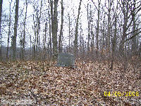
|
Cemetery Reading
| |||||||||||||||||||||||||||||||||||||||||||
| Cemetery Name: |
Samuel Greenberry Haynes |
Click on photo above to enlarge |
| County: | Kanawha | |
| USGS Quad: | Romance Map | |
| Coordinates: | 38.5950ºN -81.5179ºW | |
| Maintained by: | unknown | |
| Land owner: | unknown | |
| Date added to WVCPA register: | March 2009 | |
| Condition of cemetery**: | Poor (March 2009) | |
| Accessibility: | The Cemetery is located in a remote location accessed from Allens Branch. Locating the cemetery is difficult. It requires walking abandoned gas well and logging roads for approximately 1.5 miles. From Charleston, travel I-77N to Exit 116, turn right and travel approximately 200' to CR-21. Turn right on CR-21, travel approximately 1/2 mile, turn left onto Poca River Road (CR-33). Proceed on Poca River Road for 5.1 miles, turn left across bridge onto Cicerone Road. Cicerone Road maintains the CR-33 designation. Travel 4.0 miles to Allens Branch CR 33/8. Turn left on Allens Branch and travel .85 miles to a private driveway. Park along Allens Branch Road, walk the remaining 1.5 miles. | |
|
** Condition of cemetery as
observed on the given date - |
||
| Last Name: | First Name: |
Born: |
Died: |
Inscription: |
Photo: |
Source: |
|
Haynes |
Samuel Greenberry | 1858 | 1932 |
"Father" [Husband and wife - shared stone] "Mother" |
|
|
| Haynes | Mary Alice | 1863 | 1942 |
| Comments: |
Dates in Red
are not inscribed on the tombstone and have either been calculated based on
death date or are as a result of research on the individual. Comments from our volunteers who contributed this information, Charlotte & Steve Iman:
"Two graves were marked with a shared monument and foot stones. We were
unable to clearly identify any other graves, but observed 4 depressions
which could possibly be unmarked graves. Cemetery appears to receive
occasional attention, possibly every 2-3 years."
|
Updated: 07 September 2012
